

Rock Beach
Location:
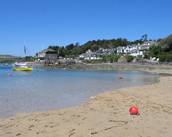
North Cornwall.Description:
Rock Beach is a long sandy beach on the east side of the Camel Estuary. At low tide Rock Beach stretches from Porthilly Cove north to Daymer Bay. The best of the sand is beyond the ferry pontoon. There are also extensive sand dunes. There is a passenger ferry between Rock Beach and Padstow on the opposite side of the Camel Estuary.Safety:
Signs warn of strong tidal currents and boat movements making it unsafe to swim out of your depth. Attempting to cross the river is very dangerous. See Beach Safety Guide.Access:
There are two slipways from the road to the beach, suitable for disabled access. There are steps from the car park to the beach.Dogs:
Dogs allowed all year on Rock Beach.Directions:
Rock is approximately 6 miles from Wadebridge and 13 miles from Bodmin. Approach Wadebridge on the A389 (from Bodmin) or the A39. At the roundabout on the outskirts of Wadebridge, turn onto the B3314 (signposted to Polzeath and Rock). Then at a mini-roundabout turn right to continue on the B3314 (again signposted to Polzeath, Rock and St Minver). After about 3-4 miles on this road, turn left where signposted to Rock and follow this road down to Rock.Post Code:
PL27 6LD.Parking:
1 car park by Rock Beach.Toilets:
Yes, in the Rock Beach car park.Facilities:
Café, beach shop.Activities:
Ferry from Rock Beach to Padstow.Nearby Alternative Beaches:
Padstow (14 miles, harbour town, sandy beaches, part dog friendly)
Daymer Bay (3 miles, sandy beach, dog friendly)
Polzeath (3 miles, sandy beach, surfing, disabled access)


Photos of Rock Beach provided by West Country Views
For more photos of Rock Beach, visit Rock Photos
For more photos of Rock Beach, visit Rock Photos